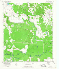
1965 Map of Boxelder
USGS Topo · Published 1967About this map
The Sulphur River carves a meandering southern boundary for this portion of Red River County, where the landscape transitions from the river bottomlands to the elevations of Stockbridge Knoll and Pigpen Knoll. At the center of the local community, Boxelder and the nearby Salem Ch serve as focal points for the rural population during the mid-1960s. The northern reaches are defined by a complex network of tributaries including Cuthand Creek, Kickapoo Creek, and White Oak Creek, while Evergreen Cem provides a specific point of interest for genealogists tracing area families. The southern portion of the map reveals the industrial footprint of the era, notably the Trix-Liz Oil Field and various isolated oil and flowing wells. Water features like Turner Lake and Little Grass Lake dot the wetlands near the Red River and Titus County line, showing the natural hydrology before extensive modern alterations.
Find a feature on this map
34 named features on this map. Tap any name to fly to it.
Don’t see what you’re looking for? This feature index may not catch every label — zoom into the map to look around manually.
Map Details
Editions of this 1965 Boxelder Map
2 editions found
Other maps of this area

1950 · Annona
USGS Topo · 1:24,000

1951 · Annona
USGS Topo · 1:24,000

1951 · Avery
USGS Topo · 1:24,000

1953 · Texarkana
USGS Topo · 1:250,000

1956 · Texarkana
USGS Topo · 1:250,000

1964 · Cuthand
USGS Topo · 1:24,000

1964 · Wilkinson
USGS Topo · 1:24,000

1964 · Talco
USGS Topo · 1:24,000
1964 · Clarksville
USGS Topo · 1:24,000

1965 · Lydia
USGS Topo · 1:24,000