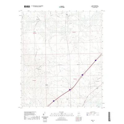
2020 Map of Boyd
USGS Topo · Published 2020About this map
York anchors the southern portion of this Sumter County landscape, where the local terrain is defined by a dense network of waterways feeding into the Sucarnoochee River. Small rural settlements like Payneville, Boyd, and Millville are connected by a web of county roads and named routes such as Fred Dial Rd and Browns Towe Rd. The map reveals a high concentration of small family and community burial grounds, including the Old Mount Olive Cem and Mount Herman Cem, which serve as vital markers for genealogical research in this part of Alabama. The geography is further characterized by numerous creek systems, from Barebone Cr to White Hall Cr, which have historically shaped the agricultural and residential patterns of the area. Modern developments like Elmwood Memorial Estates and the Sumter Academy Rd corridor indicate the evolving land use around the northern outskirts of the town of York.
Find a feature on this map
50 named features on this map. Tap any name to fly to it.
Don’t see what you’re looking for? This feature index may not catch every label — zoom into the map to look around manually.
Map Details
Editions of this 2020 Boyd Map
This is the sole edition of this map. No revisions or reprints were ever made.
Other maps of this area

1929 · Epes
USGS Topo · 1:48,000

1932 · Epes
USGS Topo · 1:62,500

1953 · Meridian
USGS Topo · 1:250,000

1957 · Meridian
USGS Topo · 1:250,000

1965 · Meridian
USGS Topo · 1:250,000

1971 · Bellamy
USGS Topo · 1:24,000

1974 · Boyd
USGS Topo · 1:24,000
1974 · Tamola
USGS Topo · 1:24,000
1974 · Epes West
USGS Topo · 1:24,000
1974 · Emelle
USGS Topo · 1:24,000