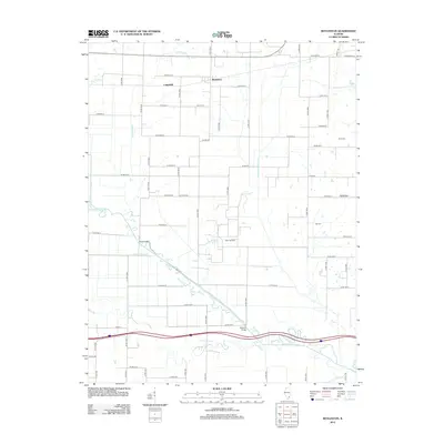
2012 Map of Boyleston
USGS Topo · Published 2012About this map
Skillet Fork meanders through this section of Wayne County, defining a landscape shaped by both its natural waterways and an extensive grid of agricultural drainage. The water management system is evident in features like the Big Mound Drainage Ditch and Eagle Slough Drainage Ditch, which support the surrounding farmland. Small settlements such as Boyleston and Campbell anchor the rural road network, while the Aden Oil Field indicates the region's industrial connection to subsurface resources. Genealogists will find interest in the locations of Clark Cem and Hall Cem, situated away from the primary villages. The infrastructure of the area is further marked by historic crossing points like Reed Bridge and Lakeside Bridge, which span the intricate curves of the river and its associated Skillet Fork Lagoon.
Find a feature on this map
66 named features on this map. Tap any name to fly to it.
Don’t see what you’re looking for? This feature index may not catch every label — zoom into the map to look around manually.
Map Details
Editions of this 2012 Boyleston Map
This is the sole edition of this map. No revisions or reprints were ever made.
Other maps of this area

1941 · Enfield
USGS Topo · 1:62,500

1942 · McLeansboro
USGS Topo · 1:62,500

1944 · Enfield
USGS Topo · 1:62,500

1945 · McLeansboro
USGS Topo · 1:62,500

1947 · Wayne City
USGS Topo · 1:62,500

1948 · Fairfield
USGS Topo · 1:62,500

1958 · Belleville
USGS Topo · 1:250,000

1962 · Belleville
USGS Topo · 1:250,000
1970 · Geff
USGS Topo · 1:24,000
1971 · Boyleston
USGS Topo · 1:24,000