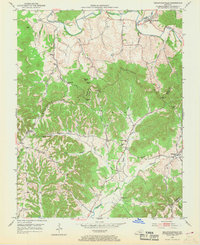
1952 Map of Bradfordsville
USGS Topo · Published 1969About this map
The Rolling Fork river system anchors this mid-century portrait of Central Kentucky, where the North Fork and South Fork converge near the community of Bradfordsville. The landscape is dominated by the prominent rise of Muldraugh Hill, a topographic feature that shapes the local drainage patterns for Arbuckle Creek and Tallow Creek. This 1952 field survey reveals a rural society structured around small, local institutions. Numerous country schools, including Grundy Sch and Reed Sch, are scattered throughout the hills alongside landmarks like Mission Ch and Liberty Ch. Small crossroads and riverside settlements like Greenbriar, Merrimac, and Salleetown appear during a period of agricultural stability, linked by narrow routes through gaps in the ridge-line such as Stayton Gap and Grindstone Gap.
Find a feature on this map
47 named features on this map. Tap any name to fly to it.
Don’t see what you’re looking for? This feature index may not catch every label — zoom into the map to look around manually.
Map Details
Editions of this 1952 Bradfordsville Map
2 editions found
Other maps of this area

1952 · Clementsville
USGS Topo · 1:24,000

1952 · Mannsville
USGS Topo · 1:24,000

1952 · Bradfordsville
USGS Topo · 1:24,000

1953 · Campbellsville
USGS Topo · 1:24,000

1953 · Bradfordsville NE
USGS Topo · 1:24,000

1953 · Gravel Switch
USGS Topo · 1:24,000

1953 · Lebanon East
USGS Topo · 1:24,000

1953 · Spurlington
USGS Topo · 1:24,000

1953 · Lebanon West
USGS Topo · 1:24,000

1953 · Bradfordsville
USGS Topo · 1:24,000