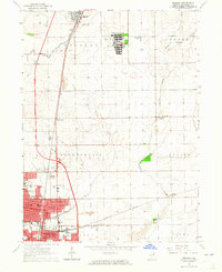
1964 Map of Bradley
USGS Topo · Published 1965About this map
The sprawling campus of the Manteno State Hospital dominates the northern landscape of this mid-1960s Kankakee County survey. To the south, the sister communities of Bradley and Bourbonnais show significant post-war expansion, anchored by educational institutions like Olivet College and Bradley-Bourbonnais High Sch. The industrial and logistics foundations of the region are clearly defined by the parallel routes of the Illinois Central and New York Central railroads, which facilitated the growth of nearby Manteno and the northern reaches of Kankakee. Beyond the urban centers, the terrain is shaped by the drainage patterns of Soldier Creek and Exline Slough, with the small settlement of St George providing a focal point for the rural townships of Ganeer and Sumner. Local historical details are abundant, including the State Hospital Cemetery and several parochial schools like St Joseph Sch and St Patricks High Sch.
Find a feature on this map
34 named features on this map. Tap any name to fly to it.
Don’t see what you’re looking for? This feature index may not catch every label — zoom into the map to look around manually.
Map Details
Editions of this 1964 Bradley Map
3 editions found
Other maps of this area

1922 · Momence
USGS Topo · 1:62,500

1922 · Kankakee
USGS Topo · 1:62,500

1924 · Momence
USGS Topo · 1:62,500

1924 · Kankakee
USGS Topo · 1:62,500

1949 · Peotone
USGS Topo · 1:62,500

1949 · Crete
USGS Topo · 1:62,500

1953 · Beecher West
USGS Topo · 1:24,000

1953 · Peotone
USGS Topo · 1:24,000

1953 · Wilton Center
USGS Topo · 1:24,000

1953 · Chicago
USGS Topo · 1:250,000