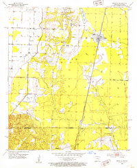
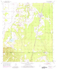
1952 Map of Bradley
USGS Topo · Published 1953About this map
Bradley serves as the primary hub of this 1950s Arkansas landscape, situated along the St Louis Southwestern railroad just north of the Arkansas Louisiana state line. The survey captures a rural network of small communities and family landmarks, including Walnut Hill and the settlement of Gin City. A significant portion of the eastern terrain is dedicated to the State Game Refuge Boundary, while the western area is defined by the winding course of Posten Bayou and Enyart Lake.
Find a feature on this map
28 named features on this map. Tap any name to fly to it.
Don’t see what you’re looking for? This feature index may not catch every label — zoom into the map to look around manually.
Map Details
Editions of this 1952 Bradley Map
6 editions found
Other maps of this area

1932 · Hosston NE
USGS Topo · 1:31,680

1948 · Vivian
USGS Topo · 1:62,500

1950 · Plain Dealing NE
USGS Topo · 1:31,680

1950 · Plain Dealing NW
USGS Topo · 1:31,680

1952 · Doddridge SE
USGS Topo · 1:24,000

1952 · Bradley
USGS Topo · 1:24,000

1952 · Bradley NE
USGS Topo · 1:24,000

1952 · Doddridge NE
USGS Topo · 1:24,000

1952 · Canfield
USGS Topo · 1:24,000

1952 · Bradley SE
USGS Topo · 1:24,000