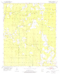
1952 Map of Bradley NE
USGS Topo · Published 1976About this map
The State Game Refuge dominates the southern landscape of this Lafayette County region, where the terrain transitions from the elevations of Marsh Hill down toward the bottomlands of Bodcau Creek. The settlement pattern in the early 1950s is defined by a network of rural roads connecting small community anchors, particularly a high density of country churches and family burial grounds. Notable landmarks include Crossroads Ch, Piney Grove Ch, and St Jonah Ch, while the St Louis Southwestern railroad cuts through the western edge of the sheet. In the northeast, the land is marked by small-scale industrial activity such as a Gravel Pit. Genealogists will find significant value in the distribution of sites like McClendon Cem, Demoss Cem, and the Primitive Cem, which are scattered throughout the low-lying drainage of Walker Creek and Heirs Branch.
Find a feature on this map
25 named features on this map. Tap any name to fly to it.
Don’t see what you’re looking for? This feature index may not catch every label — zoom into the map to look around manually.
Map Details
Editions of this 1952 Bradley NE Map
4 editions found
Other maps of this area

1952 · Bradley
USGS Topo · 1:24,000

1952 · Garland
USGS Topo · 1:24,000

1952 · Bradley NE
USGS Topo · 1:24,000

1952 · Canfield
USGS Topo · 1:24,000

1952 · Lewisville
USGS Topo · 1:24,000

1952 · Bradley SE
USGS Topo · 1:24,000

1953 · El Dorado
USGS Topo · 1:250,000

1957 · El Dorado
USGS Topo · 1:250,000

1958 · El Dorado
USGS Topo · 1:250,000

1960 · El Dorado
USGS Topo · 1:250,000