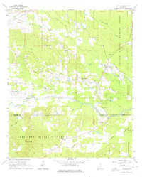
1965 Map of Bradley
USGS Topo · Published 1976About this map
The Noxubee River winds through this mid-1960s landscape, marking the boundary between Oktibbeha and Winston Counties. The area is characterized by a dense network of watercourses and protected lands, with the Noxubee National Wildlife Refuge dominating the eastern section and the Tombigbee National Forest covering the southern reaches. These public lands are interspersed with small, enduring rural communities such as Bradley and Morgantown.
Find a feature on this map
34 named features on this map. Tap any name to fly to it.
Don’t see what you’re looking for? This feature index may not catch every label — zoom into the map to look around manually.
Map Details
Editions of this 1965 Bradley Map
3 editions found
Other maps of this area

1953 · West Point
USGS Topo · 1:250,000

1958 · West Point
USGS Topo · 1:250,000

1963 · West Point
USGS Topo · 1:250,000

1965 · Starkville
USGS Topo · 1:24,000

1965 · Bluff Lake
USGS Topo · 1:24,000

1965 · Longview
USGS Topo · 1:24,000

1965 · Bradley
USGS Topo · 1:24,000

1972 · Louisville North
USGS Topo · 1:24,000

1972 · Double Springs
USGS Topo · 1:24,000

1972 · Sturgis
USGS Topo · 1:24,000