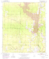
1952 Map of Bradley SE
USGS Topo · Published 1981About this map
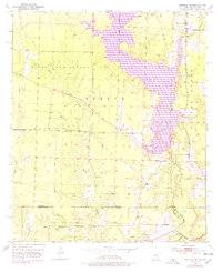
Lake Erling dominates the central topography of this 1950s landscape, which spans the border between Arkansas and Louisiana. The region is characterized by an extensive network of waterways, including Walker Creek and Bayou Bodcau, that crisscross a landscape shaped by industrial resource extraction. The presence of the Frenchman Gas Field and the North Carterville Field indicates the importance of oil and gas production to the local economy during this era. Scattered throughout the rural terrain are essential community anchors such as Walker Creek Sch, Shiloh Ch, and State Line Ch, providing valuable touchpoints for genealogists. Environmental conservation and management are also evident through the State Game Refuge and a dedicated Fish Hatchery near the lake's northern reaches.
Find a feature on this map
24 named features on this map. Tap any name to fly to it.
Don’t see what you’re looking for? This feature index may not catch every label — zoom into the map to look around manually.
Map Details
Editions of this 1952 Bradley SE Map
6 editions found
Other maps of this area

1922 · Sarepta
USGS Topo · 1:62,500

1924 · Sarepta
USGS Topo · 1:62,500

1950 · Plain Dealing NE
USGS Topo · 1:31,680

1950 · Plain Dealing NW
USGS Topo · 1:31,680

1952 · Bradley
USGS Topo · 1:24,000

1952 · Bradley NE
USGS Topo · 1:24,000

1952 · Canfield
USGS Topo · 1:24,000

1952 · Bradley SE
USGS Topo · 1:24,000

1953 · Carterville
USGS Topo · 1:24,000

1953 · El Dorado
USGS Topo · 1:250,000