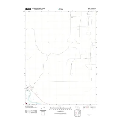
2011 Map of Brady
USGS Topo · Published 2011About this map
Brady sits at the southwestern edge of this survey, anchored by the Platte River and the local Brady Post Office. The landscape is defined by a rigid grid of rural roads, many bearing family and descriptive names such as E Antelope Rd and SW Pawnee Rd. This pattern reflects the agricultural development of Lincoln County in the early twenty-first century, where the transition from river bottomlands to upland plains is marked by organized land divisions. To the north, the isolated Antelope Cemetery serves as a significant genealogical marker for the surrounding rural community. The transportation network is anchored by E Railway St in the village, following the historical alignment of the rail corridor that parallels the river valley, while S Brady Rd provides the primary north-south artery connecting the town to the outlying farmstead territories.
Find a feature on this map
15 named features on this map. Tap any name to fly to it.
Don’t see what you’re looking for? This feature index may not catch every label — zoom into the map to look around manually.
Map Details
Editions of this 2011 Brady Map
This is the sole edition of this map. No revisions or reprints were ever made.
Other maps of this area

1902 · Gothenburg
USGS Topo · 1:125,000

1954 · McCook
USGS Topo · 1:250,000

1954 · North Platte
USGS Topo · 1:250,000

1956 · North Platte
USGS Topo · 1:250,000

1957 · North Platte
USGS Topo · 1:250,000

1957 · McCook
USGS Topo · 1:250,000

1958 · McCook
USGS Topo · 1:250,000

1967 · North Platte
USGS Topo · 1:250,000
1970 · Gothenburg
USGS Topo · 1:24,000
1970 · Brady SW
USGS Topo · 1:24,000