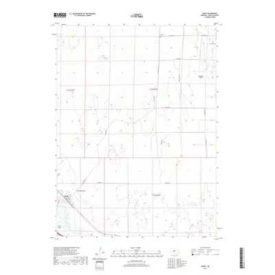
2017 Map of Brady
USGS Topo · Published 2017About this map
The Platte River flows along the southwestern edge of this Lincoln County survey, defining the landscape near the town of Brady. This area is characterized by the transition from the river bottomlands to the elevated terrain of Wild Horse Valley in the northeast. The village of Brady is centered around the intersection of N Main St and E Railway St, reflecting its historical development alongside the rail corridor. Local genealogy and history are anchored by several sites, including the Brady Cem west of town and the more isolated Antelope Cem located in the northern reaches of the quadrangle. A network of rural roads such as Wild Horse Rd and Fairview Rd connects the scattered homesteads across the townships of t12n r26w and t13n r27w, illustrating the agricultural layout of the Nebraska plains.
Find a feature on this map
22 named features on this map. Tap any name to fly to it.
Don’t see what you’re looking for? This feature index may not catch every label — zoom into the map to look around manually.
Map Details
Editions of this 2017 Brady Map
This is the sole edition of this map. No revisions or reprints were ever made.
Other maps of this area

1902 · Gothenburg
USGS Topo · 1:125,000

1954 · McCook
USGS Topo · 1:250,000

1954 · North Platte
USGS Topo · 1:250,000

1956 · North Platte
USGS Topo · 1:250,000

1957 · North Platte
USGS Topo · 1:250,000

1957 · McCook
USGS Topo · 1:250,000

1958 · McCook
USGS Topo · 1:250,000

1967 · North Platte
USGS Topo · 1:250,000
1970 · Gothenburg
USGS Topo · 1:24,000
1970 · Brady SW
USGS Topo · 1:24,000