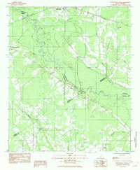
1982 Map of Branchville South
USGS Topo · Published 1983About this map
Edisto River meanders through the heart of this Lowcountry landscape, serving as a natural boundary between Orangeburg, Bamberg, Colleton, and Dorchester counties. The river corridor is defined by complex wetlands and numerous tributaries like Brier Creek, Pen Branch, and Bush Branch. In the early 1980s, the rural character of the region remained strong, centered around established settlements like Branchville and smaller junctions such as Farrell Crossroads. Local heritage is anchored by a network of country churches, including Edisto Ch, Mack Branch Ch, and Lovely Hill Ch, which appear alongside family landmarks like the Mc Alhany Cem. Transportation patterns reflect the area's history, with the Southern railroad line cutting through the northeast corner and the Sandy Island Bridge providing a critical crossing over the main river channel. The map provides a detailed view of the drainage patterns of Buckhead Creek and Brickhouse Branch as they feed into the larger river system.
Find a feature on this map
24 named features on this map. Tap any name to fly to it.
Don’t see what you’re looking for? This feature index may not catch every label — zoom into the map to look around manually.
Map Details
Editions of this 1982 Branchville South Map
This is the sole edition of this map. No revisions or reprints were ever made.
Other maps of this area

1919 · Lodge
USGS Topo · 1:62,500

1920 · Bowman
USGS Topo · 1:48,000

1920 · Lodge
USGS Topo · 1:48,000

1920 · Orangeburg
USGS Topo · 1:48,000

1920 · St. George
USGS Topo · 1:48,000

1921 · Orangeburg
USGS Topo · 1:62,500

1921 · Lodge
USGS Topo · 1:62,500

1921 · Bowman
USGS Topo · 1:62,500

1921 · St. George
USGS Topo · 1:62,500

1943 · Bowman
USGS Topo · 1:62,500