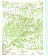
1984 Map of Brazos West
USGS Topo · Published 1984About this map
The Brazos River carves a dramatic, winding path through this corner of Palo Pinto County, creating a series of distinctive landforms including Village Bend, John Hittson Bend, and Chestnut Bend. This 1970s field-checked survey reveals a landscape of high relief where Robinson Mountain stands over the drainage systems of Palo Pinto Creek and Buck Creek. The small community of Brazos serves as a local anchor near the river's crossing, while the area around Baker and Pleasant Valley to the north reflects the rural settlement patterns of north-central Texas. Notable for genealogists and local historians are the numerous named bends and hollows, such as Hogpen Hollow and Edmondson Bend, which often preserve the surnames of early ranching and farming families who settled along the river's fertile but complex floodplain.
Find a feature on this map
22 named features on this map. Tap any name to fly to it.
Don’t see what you’re looking for? This feature index may not catch every label — zoom into the map to look around manually.
Map Details
Editions of this 1984 Brazos West Map
2 editions found
Other maps of this area

1891 · Palo Pinto
USGS Topo · 1:125,000

1918 · Palo Pinto
USGS Topo · 1:125,000

1925 · Palo Pinto 4-b
USGS Topo · 1:48,000

1927 · Pickwick
USGS Topo · 1:62,500

1927 · Mineral Wells
USGS Topo · 1:62,500

1931 · Santo
USGS Topo · 1:62,500

1954 · Abilene
USGS Topo · 1:250,000

1958 · Abilene
USGS Topo · 1:250,000

1958 · Palo Pinto
USGS Topo · 1:62,500
1959 · Mineral Wells
USGS Topo · 1:62,500