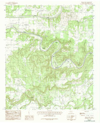
1984 Map of Brazos West
USGS Topo · Published 1987About this map
The Brazos River creates a serpentine corridor through Palo Pinto County, defined by a dramatic series of named loops including John Hittson Bend, Chestnut Bend, and Polk Stalk Bend. This 1984 survey documents a landscape where agricultural life clings to the fertile lowlands of Pleasant Valley and Village Bend, while the surrounding terrain rises toward prominent elevations like Robinson Mountain. The small settlement of Brazos sits near the eastern edge of the quadrangle, connected to the broader region by a network of unimproved roads and trails. Evidence of early local history is found at the Cem near the river, while a complex drainage system featuring Hogpen Hollow, Rock Creek, and Palo Pinto Creek illustrates the intricate topography of this North Central Texas region.
Find a feature on this map
20 named features on this map. Tap any name to fly to it.
Don’t see what you’re looking for? This feature index may not catch every label — zoom into the map to look around manually.
Map Details
Editions of this 1984 Brazos West Map
2 editions found
Other maps of this area

1891 · Palo Pinto
USGS Topo · 1:125,000

1918 · Palo Pinto
USGS Topo · 1:125,000

1925 · Palo Pinto 4-b
USGS Topo · 1:48,000

1927 · Pickwick
USGS Topo · 1:62,500

1927 · Mineral Wells
USGS Topo · 1:62,500

1931 · Santo
USGS Topo · 1:62,500

1954 · Abilene
USGS Topo · 1:250,000

1958 · Abilene
USGS Topo · 1:250,000

1958 · Palo Pinto
USGS Topo · 1:62,500
1959 · Mineral Wells
USGS Topo · 1:62,500