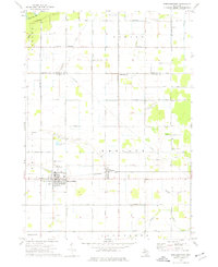
1973 Map of Breckenridge
USGS Topo · Published 1977About this map
The Chesapeake and Ohio railroad corridor serves as the primary east-west spine for this 1970s landscape, anchoring the village of Breckenridge and the smaller settlement of Wheeler. This transition between the townships of Jasper, Bethany, and Wheeler reflects a highly organized agricultural grid, interrupted only by the diagonal paths of industrial pipelines and the Migrant Workers Camp near the eastern border. To the north, the Porter Oil Field and scattered gravel pits point to the region's extraction history, while the Pine River and Bush Creek define the northern drainage patterns.
Find a feature on this map
38 named features on this map. Tap any name to fly to it.
Don’t see what you’re looking for? This feature index may not catch every label — zoom into the map to look around manually.
Map Details
Editions of this 1973 Breckenridge Map
This is the sole edition of this map. No revisions or reprints were ever made.
Other maps of this area

1930 · Shepherd
USGS Topo · 1:48,000

1934 · Sanford
USGS Topo · 1:62,500

1934 · Merrill
USGS Topo · 1:62,500

1935 · Alma
USGS Topo · 1:62,500

1936 · Shepherd
USGS Topo · 1:62,500

1936 · Sanford
USGS Topo · 1:62,500

1937 · Merrill
USGS Topo · 1:62,500

1938 · Alma
USGS Topo · 1:62,500

1954 · Midland
USGS Topo · 1:250,000

1958 · Midland
USGS Topo · 1:250,000