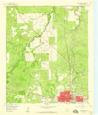
1958 Map of Breckenridge
USGS Topo · Published 1959About this map
The county seat of Breckenridge is the focal point of this 1950s survey, revealing a post-war Texas landscape defined by petroleum infrastructure and local institutional growth. Significant urban markers include the Courthouse, the Stephens Memorial Hosp, and a grid of residential streets such as Walker St and Elliot St. The map captures the era's social and industrial footprint through the presence of a Drive-in Theater, a Golf Course, and numerous Sludge Pits scattered near the city limits, indicating the proximity of oil field operations.
Find a feature on this map
32 named features on this map. Tap any name to fly to it.
Don’t see what you’re looking for? This feature index may not catch every label — zoom into the map to look around manually.
Map Details
Editions of this 1958 Breckenridge Map
Other maps of this area

1890 · Breckenridge
USGS Topo · 1:125,000

1892 · Albany
USGS Topo · 1:125,000

1893 · Albany
USGS Topo · 1:125,000

1954 · Abilene
USGS Topo · 1:250,000

1958 · Abilene
USGS Topo · 1:250,000

1958 · Breckenridge
USGS Topo · 1:24,000

1958 · Edwards Branch
USGS Topo · 1:24,000

1961 · Buck Mountain
USGS Topo · 1:24,000

1961 · Eolian
USGS Topo · 1:24,000

1965 · Lusk
USGS Topo · 1:24,000