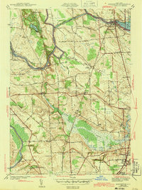
1943 Map of Brewerton
USGS Topo · Published 1943About this map
The Oneida River and Oswego Canal define the industrial and transit character of this Central New York landscape during the early 1940s. Centered on the village of Brewerton, the map illustrates a complex network of waterways where the Barge Canal intersects with natural river courses, supported by infrastructure like Lock 23 and the Schroeppel Bridge. The region is a mix of small agricultural hamlets and growing suburban outskirts, featuring numerous named rural schools such as Becker Sch, Sand Ridge Sch, and the uniquely named Mud Mill Sch.
Find a feature on this map
69 named features on this map. Tap any name to fly to it.
Don’t see what you’re looking for? This feature index may not catch every label — zoom into the map to look around manually.
Map Details
Editions of this 1943 Brewerton Map
2 editions found

Other maps of this area

1895 · Syracuse
USGS Topo · 1:62,500

1898 · Syracuse
USGS Topo · 1:62,500

1900 · Baldwinsville
USGS Topo · 1:62,500

1900 · Fulton
USGS Topo · 1:62,500

1905 · Mexico
USGS Topo · 1:62,500

1938 · Syracuse East
USGS Topo · 1:24,000

1939 · Syracuse West
USGS Topo · 1:24,000

1940 · Brewerton
USGS Topo · 1:24,000

1940 · Cicero
USGS Topo · 1:24,000
1943 · Syracuse East
USGS Topo · 1:31,680