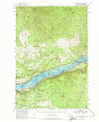
1954 Map of Bridal Veil
USGS Topo · Published 1974About this map
Columbia River gorge architecture and the mid-century transportation corridor dominate this landscape where the Skamania Co Multnomah Co line splits the water. The map documents an era when the Spokane Portland and Seattle Railway and the Union Pacific Railroad hugged opposite banks, serving riverside settlements like Warrendale, Dodson, and Prindle. The verticality of the gorge is evident in the cluster of famous cataracts including Multnomah Falls, Bridal Veil Falls, and Latourell Falls, many of which were accessible via the Old Columbia River Highway. To the north, the terrain rises toward the Gifford Pinchot National Forest, where resource extraction and forest management are marked by the Last Chance Mine and the Washougal Ranger Sta. Prominent monoliths like Beacon Rock and high points such as Larch Mtn and Silver Star Mtn define the horizon above the industrial river valley.
Find a feature on this map
98 named features on this map. Tap any name to fly to it.
Don’t see what you’re looking for? This feature index may not catch every label — zoom into the map to look around manually.
Map Details
Editions of this 1954 Bridal Veil Map
4 editions found

Other maps of this area

1911 · Boring
USGS Topo · 1:48,000

1914 · Boring
USGS Topo · 1:62,500

1916 · Estacada
USGS Topo · 1:125,000

1918 · Troutdale
USGS Topo · 1:62,500

1924 · Mount Hood
USGS Topo · 1:125,000

1926 · Hood River
USGS Topo · 1:125,000

1927 · Mount Hood
USGS Topo · 1:125,000

1929 · Hood River
USGS Topo · 1:125,000

1934 · Troutdale
USGS Topo · 1:48,000

1940 · Lookout Mtn
USGS Topo · 1:62,500