
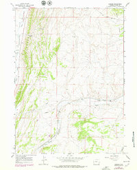
1965 Map of Bridger
USGS Topo · Published 1968About this map
The Union Pacific railroad corridor defines the southern landscape of this mid-1960s Uinta County survey, tracing the winding path of Muddy Creek near the small settlement of Bridger. This area serves as a critical transportation artery through the high desert, where the Carter Cutoff Road provides transit across the northern reaches. The terrain is marked by distinctive geological formations, including the prominent north-south ridge known as the Hogsback, which rises above Cumberland Flats.
Find a feature on this map
16 named features on this map. Tap any name to fly to it.
Don’t see what you’re looking for? This feature index may not catch every label — zoom into the map to look around manually.
Map Details
Editions of this 1965 Bridger Map
2 editions found
Other maps of this area

1954 · Ogden
USGS Topo · 1:250,000

1958 · Ogden
USGS Topo · 1:250,000

1960 · Ogden
USGS Topo · 1:250,000

1962 · Cumberland Gap
USGS Topo · 1:24,000

1962 · Elkol SW
USGS Topo · 1:24,000

1964 · Fort Bridger
USGS Topo · 1:24,000

1964 · Carter
USGS Topo · 1:24,000

1965 · Ragan
USGS Topo · 1:24,000

1965 · Leroy
USGS Topo · 1:24,000

1965 · Meadow Draw
USGS Topo · 1:24,000