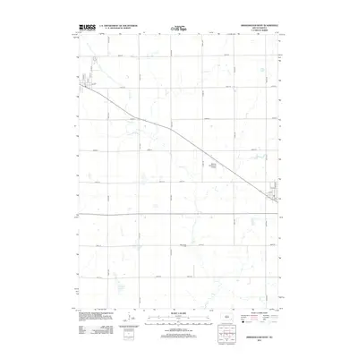
2012 Map of Bridgewater West
USGS Topo · Published 2012About this map
Wolf Cr meanders across this McCook County landscape, defining the agricultural character of the prairie just west of the town center. The 2012 survey illustrates a region shaped by a strict section-line road grid, where large-scale farming is punctuated by essential local landmarks like the Rasmussen Cem and Tschetter Slough. These features provide critical points of reference for genealogists tracing family land or naturalists studying the hydrology of the area's creeks and wetlands. Near the eastern edge, the town's street grid begins to emerge with N Main Ave and 5th St, while the Waltner & Richards Airport and the local Po serve as modern functional hubs. This map serves as a detailed record of South Dakota's rural infrastructure, from the named avenues to the drainage patterns of Elm Cr.
Find a feature on this map
26 named features on this map. Tap any name to fly to it.
Don’t see what you’re looking for? This feature index may not catch every label — zoom into the map to look around manually.
Map Details
Editions of this 2012 Bridgewater West Map
This is the sole edition of this map. No revisions or reprints were ever made.
Other maps of this area

1898 · Olivet
USGS Topo · 1:125,000

1898 · Parker
USGS Topo · 1:125,000

1899 · Alexandria
USGS Topo · 1:125,000

1955 · Sioux Falls
USGS Topo · 1:250,000

1957 · Clayton
USGS Topo · 1:24,000

1958 · Sioux Falls
USGS Topo · 1:250,000

1964 · Salem
USGS Topo · 1:24,000

1964 · Bridgewater East
USGS Topo · 1:24,000

1970 · Clayton NE
USGS Topo · 1:24,000
1970 · Dolton
USGS Topo · 1:24,000