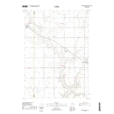
2017 Map of Bridgewater West
USGS Topo · Published 2017About this map
Bridgewater and Emery anchor this agricultural region on the boundary of Hanson and McCook counties. The landscape is defined by the winding course of Wolf Creek and its tributary Wolf Cr, which drain toward the south through a pattern of section-line roads and rolling fields. In the southwestern portion of the sheet, the wetland terrain of Tschetter Slough provides a distinct break from the surrounding grid. Notable local landmarks include the Waltner & Richards Airport situated near the center of the quadrangle and two rural burial sites, Rasmussen Cem and Bridgewater Cem. The town of Bridgewater is detailed with its street grid, featuring names like N Main Ave and E 4th St, reflecting the established community structure of the South Dakota plains during the early twenty-first century.
Find a feature on this map
38 named features on this map. Tap any name to fly to it.
Don’t see what you’re looking for? This feature index may not catch every label — zoom into the map to look around manually.
Map Details
Editions of this 2017 Bridgewater West Map
This is the sole edition of this map. No revisions or reprints were ever made.
Other maps of this area

1898 · Olivet
USGS Topo · 1:125,000

1898 · Parker
USGS Topo · 1:125,000

1899 · Alexandria
USGS Topo · 1:125,000

1955 · Sioux Falls
USGS Topo · 1:250,000

1957 · Clayton
USGS Topo · 1:24,000

1958 · Sioux Falls
USGS Topo · 1:250,000

1964 · Salem
USGS Topo · 1:24,000

1964 · Bridgewater East
USGS Topo · 1:24,000

1970 · Clayton NE
USGS Topo · 1:24,000
1970 · Dolton
USGS Topo · 1:24,000