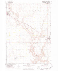
1973 Map of Bridgewater West
USGS Topo · Published 1978About this map
The agrarian boundary between Hanson and McCook Counties is defined by a network of drainage ways and rail infrastructure during the early 1970s. The Chicago Milwaukee St Paul and Pacific railroad cuts diagonally across the landscape, linking the residential blocks of Emery in the northwest to the edge of Bridgewater in the east. Wolf Creek meanders through the central terrain, its course marked by numerous Gravel Pits that suggest local extraction industries supporting the region's road and rail development.
Find a feature on this map
18 named features on this map. Tap any name to fly to it.
Don’t see what you’re looking for? This feature index may not catch every label — zoom into the map to look around manually.
Map Details
Editions of this 1973 Bridgewater West Map
This is the sole edition of this map. No revisions or reprints were ever made.
Other maps of this area

1898 · Olivet
USGS Topo · 1:125,000

1898 · Parker
USGS Topo · 1:125,000

1899 · Alexandria
USGS Topo · 1:125,000

1955 · Sioux Falls
USGS Topo · 1:250,000

1957 · Clayton
USGS Topo · 1:24,000

1958 · Sioux Falls
USGS Topo · 1:250,000

1964 · Salem
USGS Topo · 1:24,000

1964 · Bridgewater East
USGS Topo · 1:24,000

1970 · Clayton NE
USGS Topo · 1:24,000
1970 · Dolton
USGS Topo · 1:24,000