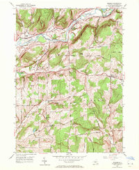
1949 Map of Brisben
USGS Topo · Published 1971About this map
The Chenango River valley serves as the primary corridor for settlement and infrastructure in this mid-century survey of New York. The landscape is defined by the sharp transition between the river bottomlands and high relief features like Harbor Hill and Watrous Hill. Evidence of nineteenth-century transportation remains visible in the form of an Abandoned Canal running parallel to the river, a relic of earlier commerce superseded by the Delaware Lackawanna and Western Road.
Find a feature on this map
46 named features on this map. Tap any name to fly to it.
Don’t see what you’re looking for? This feature index may not catch every label — zoom into the map to look around manually.
Map Details
Editions of this 1949 Brisben Map
2 editions found
Other maps of this area

1902 · Coventry
USGS Topo · 1:62,500

1904 · Binghamton
USGS Topo · 1:62,500

1904 · Greene
USGS Topo · 1:62,500

1904 · Oxford
USGS Topo · 1:62,500

1905 · Nineveh
USGS Topo · 1:62,500

1935 · Chenango Forks
USGS Topo · 1:24,000

1942 · Chenango Forks
USGS Topo · 1:31,680
1948 · Greene
USGS Topo · 1:24,000
1948 · Smithville Flats
USGS Topo · 1:24,000

1948 · Binghamton
USGS Topo · 1:250,000