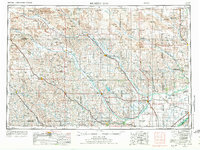
1955 Map of Broken Bow
USGS Topo · Published 1974About this map
Sand Hills topography dominates the northwestern reaches of this Central Nebraska survey, defining a landscape where ranching and river valleys dictate the pattern of settlement. Along the fertile corridors of the North Loup River, Middle Loup River, and South Loup River, established towns like Broken Bow and Ord serve as regional hubs for the surrounding agricultural community. The map captures a transition in water management and recreation with the presence of the Sherman Reservoir and Ericson Lake, while Fort Hartsuff State Historical Park preserves a tangible link to the frontier era. Transport infrastructure is anchored by the Burlington Northern and Union Pacific railroads, which parallel the river courses and connect smaller siding towns such as Anselmo, Dunning, and Mason City to the broader Midwestern rail network.
Find a feature on this map
124 named features on this map. Tap any name to fly to it.
Don’t see what you’re looking for? This feature index may not catch every label — zoom into the map to look around manually.
Map Details
Editions of this 1955 Broken Bow Map
5 editions found

Other maps of this area

1892 · Grand Island
USGS Topo · 1:62,500

1895 · Grand Island
USGS Topo · 1:62,500

1895 · Wood River
USGS Topo · 1:62,500

1896 · Lexington
USGS Topo · 1:125,000

1896 · Kearney
USGS Topo · 1:125,000

1896 · Wood River
USGS Topo · 1:125,000

1896 · Stromsburg
USGS Topo · 1:125,000

1898 · York
USGS Topo · 1:125,000

1898 · Grand Island
USGS Topo · 1:125,000

1899 · Lexington
USGS Topo · 1:125,000