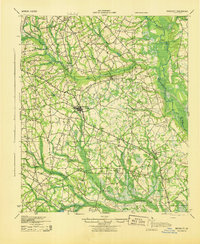
1943 Map of Brooklet
USGS Topo · Published 1943About this map
Brooklet and Stilson anchor a rural landscape defined by the winding Ogeechee River and the transit route of the Savannah & Statesboro RR. During the early 1940s, this area of Bulloch and Effingham Counties was densely populated with small local hubs, evidenced by the high frequency of community landmarks like Knight Sch, Slabville Sch, and New Fellowship Ch. The riverfront at Gobar Landing and crossings like EB Lee Ford reflect a geography still heavily reliant on natural waterways for movement and boundary-marking.
Find a feature on this map
44 named features on this map. Tap any name to fly to it.
Don’t see what you’re looking for? This feature index may not catch every label — zoom into the map to look around manually.
Map Details
Editions of this 1943 Brooklet Map
This is the sole edition of this map. No revisions or reprints were ever made.
Other maps of this area
1918 · Oliver
USGS Topo · 1:62,500
1919 · Shirley
USGS Topo · 1:62,500
1919 · Claxton
USGS Topo · 1:62,500
1919 · Egypt
USGS Topo · 1:62,500
1920 · Pembroke
USGS Topo · 1:62,500
1920 · Statesboro
USGS Topo · 1:62,500
1920 · Meldrim
USGS Topo · 1:62,500
1920 · Oliver
USGS Topo · 1:62,500
1921 · Brooklet
USGS Topo · 1:62,500
1921 · Rocky Ford
USGS Topo · 1:62,500