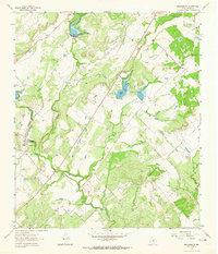
1963 Map of Brooksmith
USGS Topo · Published 1964About this map
Brookesmith and the small settlement of Dulin anchor this mid-century survey of the Brown County landscape. The area is defined by the winding course of Clear Creek and its southern tributaries, including Indian Creek. A notable vestige of earlier transportation is the Old Railroad Grade, which cuts diagonally across the terrain toward the northeast. Water management is a visible priority throughout this ranching country, evidenced by the multiple spillways and reservoirs like Coggin Lake. To the north, Jordan Springs provides a natural landmark, while several Gravel Pits indicate local extractive industry during the early 1960s. The map captures a moment when the transition from rail reliance to modern road networks was nearly complete, yet the physical scars of the old routes remained prominent features of the rural topography.
Find a feature on this map
15 named features on this map. Tap any name to fly to it.
Don’t see what you’re looking for? This feature index may not catch every label — zoom into the map to look around manually.
Map Details
Editions of this 1963 Brooksmith Map
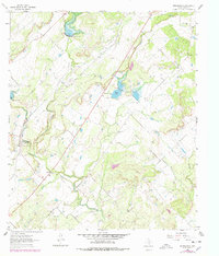
2 editions found
Other maps of this area

1885 · San Saba
USGS Topo · 1:125,000

1887 · Coleman
USGS Topo · 1:125,000

1889 · Brownwood
USGS Topo · 1:125,000

1889 · Coleman
USGS Topo · 1:125,000

1894 · Brady
USGS Topo · 1:125,000

1894 · Brownwood
USGS Topo · 1:125,000

1894 · San Saba
USGS Topo · 1:125,000

1925 · Brownwood 3-b
USGS Topo · 1:48,000

1925 · Brady 1-b
USGS Topo · 1:48,000

1925 · Brady 1-a
USGS Topo · 1:48,000