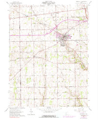
1961 Map of Brookville
USGS Topo · Published 1991About this map
Brookville and its surrounding townships define this western Ohio landscape, captured here as the area transitioned from a rail-dependent agricultural hub to a modernizing rural district. The Penn Central and Baltimore and Ohio railroads anchor the older village centers like Bachman and Dodson, while the expansion of roads such as Salem Road reflects the changing transport patterns of the mid-20th century. Local landmarks like the Basor Airport and various radio towers signal the era's technical infrastructure, yet the map maintains a strong record of earlier community life through its numerous country churches and cemeteries. Genealogists and local historians can trace the geography of established rural sites, including Shiloh Ch, Providence Ch, and the Pleasant Hill Cem, all set against a drainage network of creeks like Wolf Creek and Bear Creek.
Find a feature on this map
61 named features on this map. Tap any name to fly to it.
Don’t see what you’re looking for? This feature index may not catch every label — zoom into the map to look around manually.
Map Details
Editions of this 1961 Brookville Map
Other maps of this area

1905 · Brookville
USGS Topo · 1:62,500

1908 · Miamisburg
USGS Topo · 1:62,500

1911 · Oxford
USGS Topo · 1:62,500

1953 · Cincinnati
USGS Topo · 1:250,000

1955 · Miamisburg
USGS Topo · 1:24,000

1955 · West Milton
USGS Topo · 1:24,000
1955 · Trotwood
USGS Topo · 1:24,000

1957 · Cincinnati
USGS Topo · 1:250,000

1960 · Farmersville
USGS Topo · 1:24,000

1961 · Laura
USGS Topo · 1:24,000