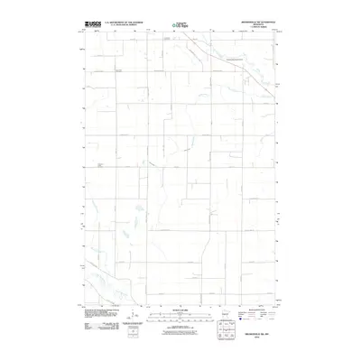
2010 Map of Browerville SW
USGS Topo · Published 2010About this map
The Long Prairie River meanders across the southwestern corner of this Todd County landscape, defining a rural region dominated by agricultural grid-lines and tributary streams. Significant local history is preserved at Evergreen Cemetery, Deer Park Cemetery, and Freemans Creek Cemetery, which serve as permanent anchors for the surrounding farmsteads. The northern portion of the map is marked by the Clarissa Municipal Airport, situated near the headwaters of Eagle Creek. Drainage patterns throughout the quadrangle are dictated by numerous small waterways, including Harris Creek, Drayer Creek, and Freemans Creek, which transition from seasonal runs into more established channels. The layout of county highways and local roads like Lace Wing Rd and County Hwy-11 reveals the 21st-century infrastructure of this Central Minnesota prairie and woodland environment.
Find a feature on this map
33 named features on this map. Tap any name to fly to it.
Don’t see what you’re looking for? This feature index may not catch every label — zoom into the map to look around manually.
Map Details
Editions of this 2010 Browerville SW Map
This is the sole edition of this map. No revisions or reprints were ever made.
Other maps of this area

1953 · Brainerd
USGS Topo · 1:250,000

1953 · Saint Cloud
USGS Topo · 1:250,000

1957 · Brainerd
USGS Topo · 1:250,000

1957 · Saint Cloud
USGS Topo · 1:250,000

1958 · Saint Cloud
USGS Topo · 1:250,000

1958 · Brainerd
USGS Topo · 1:250,000

1965 · Brainerd
USGS Topo · 1:250,000
1966 · Browerville
USGS Topo · 1:24,000
1966 · Browerville NE
USGS Topo · 1:24,000
1966 · Long Prairie
USGS Topo · 1:24,000