
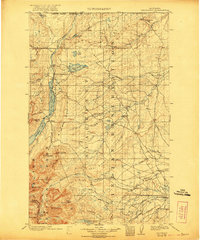
1903 Map of Browning
USGS Topo · Published 1903About this map
The Blackfeet Indian Reservation dominates the landscape of this 1903 survey, spanning from the United States Dominion of Canada Boundary Line south toward the mountainous reaches of the Flathead Forest Reserve. The map illustrates the region's hydrography as it was before major irrigation developments, centered on the Hudson Bay Divide. Waterways such as the St. Mary River, which feeds both Upper St. Mary Lake and Lower St. Mary Lake, flow north toward the Arctic, while the complex forks of the Milk River and North Fork Cutbank Creek flow east. Settlement is sparse, with Browning serving as a primary hub along the Great Northern R. R., which skirts the southern edge of the reservation. High peaks like Mt. James and Divide Mt. mark the western transition into steep alpine terrain, providing a look at this territory at the start of the 20th century.
Find a feature on this map
49 named features on this map. Tap any name to fly to it.
Don’t see what you’re looking for? This feature index may not catch every label — zoom into the map to look around manually.
Map Details
Editions of this 1903 Browning Map
2 editions found
Other maps of this area

1901 · Browning
USGS Topo · 1:125,000

1904 · Chief Mountain
USGS Topo · 1:125,000

1911 · Blackfoot
USGS Topo · 1:125,000

1913 · Marias Pass
USGS Topo · 1:125,000

1914 · Nyack
USGS Topo · 1:125,000

1914 · Heart Butte
USGS Topo · 1:125,000

1918 · Heart Butte
USGS Topo · 1:125,000

1938 · Chief Mountain
USGS Topo · 1:125,000

1960 · Cut Bank
USGS Topo · 1:250,000

1963 · Cut Bank
USGS Topo · 1:250,000