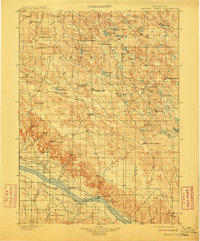
1899 Map of Browns Creek
USGS Topo · Published 1911About this map
The North Platte River corridor defines the southern boundary of this late nineteenth-century Nebraska landscape, where early irrigation systems like the Browns Creek Canal, Beerline Canal, and Belmont Canal signal the beginning of intensive agriculture. The survey reveals a region transitioning from open range to established ranching, marked by numerous family-named homesteads including Johnson's Ranch, Hague's Ranch, and Beerline's Ranch. To the north, the terrain is dotted with natural basins and water sources such as Rush Lake, Wild Horse Lake, and Camp Lake, which were vital for livestock in the semi-arid environment. Settlement hubs are sparse, represented by Orlando and Lisco, while the presence of the Camp Clarke Trail reflects the area's importance as a passage for western travel. Notable landmarks such as Courthouse Rock and Cowboy Hill provide essential orientation in this sprawling prairie.
Find a feature on this map
57 named features on this map. Tap any name to fly to it.
Don’t see what you’re looking for? This feature index may not catch every label — zoom into the map to look around manually.
Map Details
Editions of this 1899 Browns Creek Map
5 editions found
Other maps of this area

1896 · Browns Creek
USGS Topo · 1:125,000

1898 · Camp Clarke
USGS Topo · 1:125,000

1899 · Browns Creek
USGS Topo · 1:125,000

1899 · Sidney
USGS Topo · 1:125,000

1900 · Chappell
USGS Topo · 1:125,000

1947 · Alliance
USGS Topo · 1:24,000

1947 · Bronco Lake
USGS Topo · 1:24,000

1948 · Hemingford 4 SE
USGS Topo · 1:24,000

1948 · Alliance
USGS Topo · 1:24,000

1948 · Antioch
USGS Topo · 1:62,500