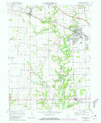
1970 Map of Brownsburg
USGS Topo · Published 1981About this map
West Fork White Lick Creek and its many tributaries carve through the heart of Hendricks County, providing the topographic backbone for the growing settlements of Brownsburg and Pittsboro. In this 1970 snapshot, the transition from agricultural land to suburban development is evident, particularly around Arbuckle Acres Park and the burgeoning residential grids north of the Conrail line. The landscape is dotted with generational landmarks, from the St Malachy West Cem and Abner Creek Cem to the historic Bartlett Chapel. Local transportation and utility infrastructure are well-documented, featuring the Baltimore and Ohio railroad corridor and the Brownsburg Airfield. The map also captures several man-made water features such as Iola Lake and Ledgewood Lake, which reflect the mid-century development of recreational and residential communities in central Indiana.
Find a feature on this map
48 named features on this map. Tap any name to fly to it.
Don’t see what you’re looking for? This feature index may not catch every label — zoom into the map to look around manually.
Map Details
Editions of this 1970 Brownsburg Map
3 editions found
Other maps of this area

1953 · Bridgeport
USGS Topo · 1:24,000

1953 · Clayton
USGS Topo · 1:24,000

1953 · Fayette
USGS Topo · 1:24,000

1953 · Lizton
USGS Topo · 1:24,000

1953 · Danville
USGS Topo · 1:24,000

1953 · Brownsburg
USGS Topo · 1:24,000

1953 · Zionsville
USGS Topo · 1:24,000

1953 · Plainfield
USGS Topo · 1:24,000

1953 · Clermont
USGS Topo · 1:24,000

1953 · Indianapolis
USGS Topo · 1:250,000