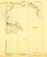
1921 Map of Brownsville
USGS Topo · Published 1927About this map
Brownsville sits at the heart of this early twentieth-century survey, where the Southern Pacific line and the Calapooya River intersect to define the local economy. The landscape is marked by small rural settlements like Sodaville and Waterloo, the latter positioned near the winding course of the South Santiam River. This era in Linn County reveals a dense network of district education, with specialized sites like Rockhill School, Oak Grove School, and Union Point School serving the surrounding agricultural valley. Notable water management is evident through features like the Warren Ditch, which redirects flow from the river through the terrain north of town. To the south, the survey traces the headwaters of several drainages, including Tub Run and Pierce Cr, near the Diamond Hill School, providing a detailed look at the land before later development altered these rural school districts and homestead patterns.
Find a feature on this map
22 named features on this map. Tap any name to fly to it.
Don’t see what you’re looking for? This feature index may not catch every label — zoom into the map to look around manually.
Map Details
Editions of this 1921 Brownsville Map
4 editions found
Other maps of this area

1909 · Rowland
USGS Topo · 1:31,680

1910 · Eugene
USGS Topo · 1:62,500

1911 · Brownsville
USGS Topo · 1:31,680

1911 · Lebanon
USGS Topo · 1:31,680

1911 · Tangent
USGS Topo · 1:31,680

1912 · Halsey
USGS Topo · 1:62,500

1916 · Albany
USGS Topo · 1:62,500

1921 · Brownsville
USGS Topo · 1:62,500

1921 · Lebanon
USGS Topo · 1:62,500

1922 · Lebanon
USGS Topo · 1:48,000