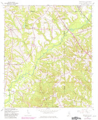
1960 Map of Brundidge SE
USGS Topo · Published 1981About this map
The Pea River meanders through this landscape on the border of Coffee, Dale, and Pike Counties, anchoring a rural network of small agricultural settlements and timber stands. Near the northern reach of the river, Prestwood Millpond and Roeton mark centers of early activity, while the Seaboard Coast Line railroad skirts the eastern edge through Tennille and Lithco. The map reveals a deeply religious community structure, evidenced by numerous rural sanctuaries such as Mt Zion Ch, Corinth Ch, and St Johns Ch, often serving as the primary landmarks for scattered farmsteads.
Find a feature on this map
40 named features on this map. Tap any name to fly to it.
Don’t see what you’re looking for? This feature index may not catch every label — zoom into the map to look around manually.
Map Details
Editions of this 1960 Brundidge SE Map
2 editions found

Other maps of this area

1942 · Enterprise
USGS Topo · 1:125,000

1948 · Ozark
USGS Topo · 1:62,500

1948 · Brundidge
USGS Topo · 1:62,500

1950 · Ozark
USGS Topo · 1:62,500

1950 · Enterprise
USGS Topo · 1:62,500

1950 · Brundidge
USGS Topo · 1:62,500

1953 · Dothan
USGS Topo · 1:250,000

1954 · Dothan
USGS Topo · 1:250,000

1955 · Dothan
USGS Topo · 1:250,000

1960 · Brundidge
USGS Topo · 1:24,000