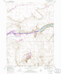
1947 Map of Bruneau Dunes
USGS Topo · Published 1986About this map
The Bruneau Dunes dominate the southern landscape of this Idaho interior, where wind-swept sands gather in a pocket known as Eagle Cove. The map documents a significant transformation of the river valley, centered on the C-j-strike Reservoir, where the waters of the Snake River have expanded to surround Wilkins Island. Along the northern banks, the terrain transitions into a series of gulches and ridges, including Browns Gulch and the prominent Flatiron Butte.
Find a feature on this map
12 named features on this map. Tap any name to fly to it.
Don’t see what you’re looking for? This feature index may not catch every label — zoom into the map to look around manually.
Map Details
Editions of this 1947 Bruneau Dunes Map
4 editions found
Other maps of this area

1892 · Mountain Home
USGS Topo · 1:125,000

1893 · Mountain Home
USGS Topo · 1:125,000

1947 · Bruneau
USGS Topo · 1:62,500

1947 · Indian Cove
USGS Topo · 1:24,000

1947 · Sand Dunes
USGS Topo · 1:24,000

1947 · Bruneau
USGS Topo · 1:24,000

1947 · Sugar Valley
USGS Topo · 1:24,000

1947 · Hot Spring
USGS Topo · 1:24,000

1948 · Sand Dunes
USGS Topo · 1:24,000

1948 · Indian Cove
USGS Topo · 1:24,000