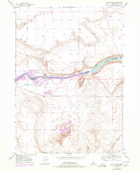
1947 Map of Sand Dunes
USGS Topo · Published 1978About this map
The Snake River corridor defines this portion of the Idaho high desert, where the waters are held by the C J Strike Reservoir. This 1947 survey, later updated with photorevisions, illustrates the complex topography where the river channel winds past Wilkins Island and under the shadow of Flatiron Butte. The landscape is a study in contrasts, from the riparian margins near Barber Cabin to the expansive Sand Dunes and the sheltered basin of Eagle Cove. Drainages like Browns Gulch and Waterhouse Gulch cut through the high ground, while Rattlesnake Sprs and Rattlesnake Creek provide seasonal water sources in the northern reaches. The map reflects the mid-century intersection of natural desert landforms and significant hydroelectric development along the Elmore and Owyhee county lines.
Find a feature on this map
12 named features on this map. Tap any name to fly to it.
Don’t see what you’re looking for? This feature index may not catch every label — zoom into the map to look around manually.
Map Details
Editions of this 1947 Sand Dunes Map
4 editions found
Other maps of this area

1892 · Mountain Home
USGS Topo · 1:125,000

1893 · Mountain Home
USGS Topo · 1:125,000

1947 · Bruneau
USGS Topo · 1:62,500

1947 · Indian Cove
USGS Topo · 1:24,000

1947 · Sand Dunes
USGS Topo · 1:24,000

1947 · Bruneau
USGS Topo · 1:24,000

1947 · Sugar Valley
USGS Topo · 1:24,000

1947 · Hot Spring
USGS Topo · 1:24,000

1948 · Sand Dunes
USGS Topo · 1:24,000

1948 · Indian Cove
USGS Topo · 1:24,000