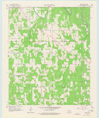
1957 Map of Bruno
USGS Topo · Published 1977About this map
Muddy Boggy Creek and its tributary, Stringtown Creek, shape the northern landscape of this rural Oklahoma territory during the mid-1950s. The area is defined by a network of small school districts and community churches that served the outlying population of Atoka County. Features such as Harmony Sch, Forest Hill Sch, and Blackjack Sch reveal the distributed nature of local education before the era of major school consolidation.
Find a feature on this map
30 named features on this map. Tap any name to fly to it.
Don’t see what you’re looking for? This feature index may not catch every label — zoom into the map to look around manually.
Map Details
Editions of this 1957 Bruno Map
3 editions found
Other maps of this area

1899 · Atoka
USGS Topo · 1:125,000

1900 · Atoka
USGS Topo · 1:125,000

1901 · Antlers
USGS Topo · 1:125,000

1912 · Antlers
USGS Topo · 1:125,000

1925 · Antlers
USGS Topo · 1:125,000

1950 · Mcalester
USGS Topo · 1:250,000

1956 · Stringtown
USGS Topo · 1:24,000

1957 · Lane NW
USGS Topo · 1:24,000

1957 · Lehigh
USGS Topo · 1:24,000

1957 · Bruno
USGS Topo · 1:24,000