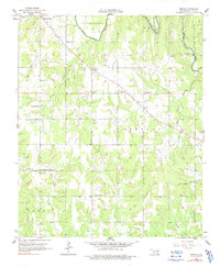
1957 Map of Bruno
USGS Topo · Published 1991About this map
Bruno sits at the center of this rural landscape in Atoka County during the mid-1950s, serving as a focal point for a region defined by its dispersed agricultural communities and winding waterways. The area is divided into historical survey districts including Stringtown, Lewis, Bentley, and Caney. The social fabric of the era is evident in the high density of country schools and churches that anchored these townships, such as Harmony Sch, Forest Hill Sch, and Vera Ch.
Find a feature on this map
26 named features on this map. Tap any name to fly to it.
Don’t see what you’re looking for? This feature index may not catch every label — zoom into the map to look around manually.
Map Details
Editions of this 1957 Bruno Map
3 editions found
Other maps of this area

1899 · Atoka
USGS Topo · 1:125,000

1900 · Atoka
USGS Topo · 1:125,000

1901 · Antlers
USGS Topo · 1:125,000

1912 · Antlers
USGS Topo · 1:125,000

1925 · Antlers
USGS Topo · 1:125,000

1950 · Mcalester
USGS Topo · 1:250,000

1956 · Stringtown
USGS Topo · 1:24,000

1957 · Lane NW
USGS Topo · 1:24,000

1957 · Lehigh
USGS Topo · 1:24,000

1957 · Bruno
USGS Topo · 1:24,000