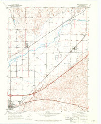
1951 Map of Brush East
USGS Topo · Published 1972About this map
The South Platte River and its accompanying irrigation network dominate this agricultural corridor in northeastern Colorado. The landscape is defined by the complex movement of water through the Lower Platte and Beaver Canal, Tremont Canal, and North Sterling Canal, supporting the regional sugar beet industry as evidenced by the Sugar Refinery at Brush. Two major railroads, the Union Pacific and the Burlington Northern, converge in this area, linking small trackside settlements like Hillrose and Snyder to wider markets. Rural education and community hubs are visible at the Fairview School and Colwell School, while more specialized infrastructure like the Municipal Airport and the Trowel Ranch reflect the mid-century evolution of the plains economy. The transition from the irrigated river bottom near Beaver Creek to the drier uplands around Dead Horse Draw illustrates the reliance on managed water systems for the region's development.
Find a feature on this map
27 named features on this map. Tap any name to fly to it.
Don’t see what you’re looking for? This feature index may not catch every label — zoom into the map to look around manually.
Map Details
Editions of this 1951 Brush East Map
4 editions found
Other maps of this area

1951 · Dead Horse Springs
USGS Topo · 1:24,000

1951 · Messex
USGS Topo · 1:24,000

1951 · Brush West
USGS Topo · 1:24,000

1951 · Antelope Springs
USGS Topo · 1:24,000

1951 · Merino SW
USGS Topo · 1:24,000

1951 · Brush East
USGS Topo · 1:24,000

1954 · Sterling
USGS Topo · 1:250,000

1958 · Sterling
USGS Topo · 1:250,000

1963 · Round Top
USGS Topo · 1:24,000

1965 · Miller Ranch
USGS Topo · 1:24,000