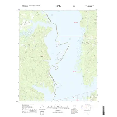
2019 Map of Brushy Creek
USGS Topo · Published 2019About this map
The Toledo Bend Reservoir dominates this landscape, serving as a significant geographical boundary between Shelby County, Texas, and Sabine Parish, Louisiana. On the Texas side, the town of Huxley sits near the northwestern corner, surrounded by the wooded expanses of the Sabine National Forest. The map reveals a complex network of sloughs and tributaries feeding into the main reservoir, including Soto Saline Slough, Kilgore Slough, and Sulphur Springs Slough. These waterways create a jagged shoreline marked by features like Browns Bend and Horseshoe Slough. Inland, the terrain is defined by numerous creek branches such as Clemens Br and Yellow Br, which drain the forest toward the reservoir. The Louisiana side of the water is accessible via local routes like Flatwood Ridge Rd and Village Rd, highlighting the interconnected nature of these rural communities along the river's edge.
Find a feature on this map
53 named features on this map. Tap any name to fly to it.
Don’t see what you’re looking for? This feature index may not catch every label — zoom into the map to look around manually.
Map Details
Editions of this 2019 Brushy Creek Map
This is the sole edition of this map. No revisions or reprints were ever made.
Other maps of this area

1941 · Zwolle
USGS Topo · 1:62,500

1941 · Pelican
USGS Topo · 1:62,500

1943 · Pleasant Hill
USGS Topo · 1:62,500

1944 · Logansport
USGS Topo · 1:62,500

1944 · Patroon
USGS Topo · 1:62,500

1944 · Zwolle
USGS Topo · 1:62,500

1944 · Pleasant Hill
USGS Topo · 1:62,500

1953 · Alexandria
USGS Topo · 1:250,000

1955 · Alexandria
USGS Topo · 1:250,000

1956 · Logansport
USGS Topo · 1:62,500