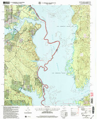
2003 Map of Brushy Creek
USGS Topo · Published 2004About this map
The Sabine River defines the winding state boundary between Texas and Louisiana on this map, which tracks the expansive waters of the Toledo Bend Reservoir. This area of the Sabine National Forest shows a landscape influenced by both timber management and recreational development. Significant land divisions like Las Ormigas Grant Lot No 1 and Las Ormigas Grant Lot No 2 reflect the colonial land grant history that still shapes property lines today.
Find a feature on this map
37 named features on this map. Tap any name to fly to it.
Don’t see what you’re looking for? This feature index may not catch every label — zoom into the map to look around manually.
Map Details
Editions of this 2003 Brushy Creek Map
This is the sole edition of this map. No revisions or reprints were ever made.
Other maps of this area

1941 · Zwolle
USGS Topo · 1:62,500

1941 · Pelican
USGS Topo · 1:62,500

1943 · Pleasant Hill
USGS Topo · 1:62,500

1944 · Logansport
USGS Topo · 1:62,500

1944 · Patroon
USGS Topo · 1:62,500

1944 · Zwolle
USGS Topo · 1:62,500

1944 · Pleasant Hill
USGS Topo · 1:62,500

1953 · Alexandria
USGS Topo · 1:250,000

1955 · Alexandria
USGS Topo · 1:250,000

1956 · Logansport
USGS Topo · 1:62,500