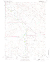
1961 Map of Bryan
USGS Topo · Published 1974About this map
Blacks Fork meanders through this high-desert landscape, creating a corridor of riparian activity that includes the historic Bryan settlement and the Lone Tree Stage Station (Site). The convergence of the Union Pacific railroad and the Overland Trail highlights the area's significance as a major transportation artery in Wyoming. Local ranching is represented by Pierotto Ranch, while the presence of Cemeteries and a Gravel Pit indicates a legacy of established habitation and early industry. To the south, the topography rises toward The Bluffs and Beacon Light Hill, with drainage provided by Meadow Springs Wash. This 1961 survey captures the area after the peak of the westward migration era, yet it preserves the clear path of the historic trail alongside the modern steel rails and utility pipelines that define the mid-century western corridor.
Find a feature on this map
15 named features on this map. Tap any name to fly to it.
Don’t see what you’re looking for? This feature index may not catch every label — zoom into the map to look around manually.
Map Details
Editions of this 1961 Bryan Map
3 editions found
Other maps of this area

1954 · Rock Springs
USGS Topo · 1:250,000

1957 · Mc Kinnon Junction
USGS Topo · 1:62,500

1958 · Rock Springs
USGS Topo · 1:250,000

1961 · Blue Point
USGS Topo · 1:24,000

1961 · Little America
USGS Topo · 1:24,000

1961 · Peru
USGS Topo · 1:24,000

1961 · Austin Ranch
USGS Topo · 1:24,000

1961 · Stevens Flat
USGS Topo · 1:24,000

1961 · Bryan
USGS Topo · 1:24,000

1962 · Rock Springs
USGS Topo · 1:250,000