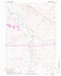
1961 Map of Bryan
USGS Topo · Published 1981About this map
Bryan and the surrounding high plains of Sweetwater County are defined by the convergence of historic transportation corridors and the winding course of Blacks Fork. This 1961 survey, updated with 1980 photorevisions, documents the legacy of the western migration through labels for the Overland Trail and the Lone Tree Stage Station (Site). The Union Pacific railroad cuts a diagonal path across the landscape, which once supported the community of Bryan as a significant railroad terminus and supply point.
Find a feature on this map
16 named features on this map. Tap any name to fly to it.
Don’t see what you’re looking for? This feature index may not catch every label — zoom into the map to look around manually.
Map Details
Editions of this 1961 Bryan Map
3 editions found
Other maps of this area

1954 · Rock Springs
USGS Topo · 1:250,000

1957 · Mc Kinnon Junction
USGS Topo · 1:62,500

1958 · Rock Springs
USGS Topo · 1:250,000

1961 · Blue Point
USGS Topo · 1:24,000

1961 · Little America
USGS Topo · 1:24,000

1961 · Peru
USGS Topo · 1:24,000

1961 · Austin Ranch
USGS Topo · 1:24,000

1961 · Stevens Flat
USGS Topo · 1:24,000

1961 · Bryan
USGS Topo · 1:24,000

1962 · Rock Springs
USGS Topo · 1:250,000