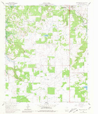
1961 Map of Buck Mountain
USGS Topo · Published 1981About this map
Curry Oil Field and numerous pipelines dominate this landscape south of Breckenridge, illustrating the intensive petroleum production in Stephens County during the early 1960s. The map captures a period of significant hydrological change as the West Central Texas Municipal Water District prepared for the inundation of Hubbard Creek Lake, with blue hatching indicating areas destined to be submerged. Local connectivity is defined by the Chicago Rock Island and Pacific railroad and the Stephens County Airport, while an Old Railroad Grade suggests an evolving transportation network. Family and community history is preserved through labels for Post Oak Cem and Hart Cem, alongside prominent local heights such as Spy Mountain, Hog Mountain, and the namesake Buck Mountain.
Find a feature on this map
24 named features on this map. Tap any name to fly to it.
Don’t see what you’re looking for? This feature index may not catch every label — zoom into the map to look around manually.
Map Details
Editions of this 1961 Buck Mountain Map
3 editions found
Other maps of this area

1890 · Breckenridge
USGS Topo · 1:125,000

1892 · Albany
USGS Topo · 1:125,000

1893 · Albany
USGS Topo · 1:125,000

1954 · Abilene
USGS Topo · 1:250,000

1958 · Abilene
USGS Topo · 1:250,000

1958 · Breckenridge
USGS Topo · 1:24,000

1958 · Edwards Branch
USGS Topo · 1:24,000

1961 · Buck Mountain
USGS Topo · 1:24,000

1961 · Eolian
USGS Topo · 1:24,000

1965 · Indian Knoll
USGS Topo · 1:24,000