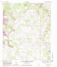
1961 Map of Buck Mountain
USGS Topo · Published 1982About this map
The Curry Oil Field and Neal Oil Field define the industrial character of this landscape south of Breckenridge in the early 1960s. The terrain is marked by prominent elevations like Spy Mountain and Buck Mountain, which overlook a network of drainage systems including Hog Branch and Gonzales Creek. An infrastructure of pipelines and an Old Railroad Grade illustrate the region's connection to petroleum extraction and historical transport. Local genealogy is anchored by the Hart Cem and Post Oak Cem, while the expansive Hubbard Creek Lake and Lake Daniel show the management of water resources in the West Central Texas Municipal Water District. The presence of the Stephens County Airport and the small settlements of Curry and South Hanlon suggest a sparsely populated but active economic corridor focused on energy and aviation.
Find a feature on this map
25 named features on this map. Tap any name to fly to it.
Don’t see what you’re looking for? This feature index may not catch every label — zoom into the map to look around manually.
Map Details
Editions of this 1961 Buck Mountain Map
3 editions found
Other maps of this area

1890 · Breckenridge
USGS Topo · 1:125,000

1892 · Albany
USGS Topo · 1:125,000

1893 · Albany
USGS Topo · 1:125,000

1954 · Abilene
USGS Topo · 1:250,000

1958 · Abilene
USGS Topo · 1:250,000

1958 · Breckenridge
USGS Topo · 1:24,000

1958 · Edwards Branch
USGS Topo · 1:24,000

1961 · Buck Mountain
USGS Topo · 1:24,000

1961 · Eolian
USGS Topo · 1:24,000

1965 · Indian Knoll
USGS Topo · 1:24,000