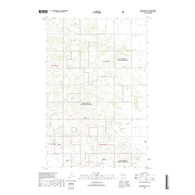
2017 Map of Buckskin Butte
USGS Topo · Published 2017About this map
Little Missouri National Grassland dominates this section of the North Dakota badlands, showing a landscape defined by dramatic topographical relief and managed conservation. The land is punctuated by distinct landmarks like Buckskin Butte and Teepee Butte, which serve as primary navigational anchors in the rolling terrain of McKenzie County. This 2017 survey details a network of section lines and forest service roads, including Co Rte 50 and 128th Ave, that provide access to this expansive public range. Waterways such as Cottonwood Cr and Bennett Cr carve through the land, illustrating the drainage patterns that have shaped the buttes over millennia. The presence of the Maah Daah Hey Trl indicates the area's importance for long-distance trail navigation, while localized road names like Main St and 2nd St SW near the eastern edge suggest the proximity of the small community of Grassy Butte.
Find a feature on this map
24 named features on this map. Tap any name to fly to it.
Don’t see what you’re looking for? This feature index may not catch every label — zoom into the map to look around manually.
Map Details
Editions of this 2017 Buckskin Butte Map
This is the sole edition of this map. No revisions or reprints were ever made.
Other maps of this area

1953 · Watford City
USGS Topo · 1:250,000

1957 · Watford City
USGS Topo · 1:250,000

1958 · Long X Divide
USGS Topo · 1:24,000

1958 · Sperati Point
USGS Topo · 1:24,000

1958 · Lone Butte
USGS Topo · 1:24,000

1967 · Watford City
USGS Topo · 1:250,000

1974 · Wolf Coulee
USGS Topo · 1:24,000

1974 · Grassy Butte SW
USGS Topo · 1:24,000

1974 · Squaretop Butte
USGS Topo · 1:24,000

1974 · Buckskin Butte
USGS Topo · 1:24,000