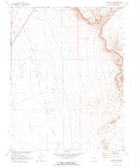
1967 Map of Buckwheat Rim
USGS Topo · Published 1973About this map
Hot Creek Valley dominates this 1967 survey, illustrating the stark geography of the high desert along the border of the Pancake Range. The landscape is defined by dramatic geological formations, including the sheer drop of Buckwheat Rim and the expansive Palisade Mesa. Human presence is minimal and functional, centered on the Blue Jay Hy Maintenance Sta and isolated industrial markers like the Gravel Pits in the northwest. Water sources are scarce in this arid basin, with Rays Well serving as a vital landmark for desert navigation. Developed in cooperation with the Atomic Energy Commission, the map meticulously records the complex relief of the Monocline and the drainage patterns of Hot Creek, capturing the area as it appeared during a period of significant federal land survey activity in central Nevada.
Find a feature on this map
12 named features on this map. Tap any name to fly to it.
Don’t see what you’re looking for? This feature index may not catch every label — zoom into the map to look around manually.
Map Details
Editions of this 1967 Buckwheat Rim Map
2 editions found
Other maps of this area

1956 · Tonopah
USGS Topo · 1:250,000

1959 · Tonopah
USGS Topo · 1:250,000

1962 · Tonopah
USGS Topo · 1:250,000

1967 · Lunar Crater
USGS Topo · 1:62,500

1967 · Blue Jay Spring
USGS Topo · 1:24,000

1967 · Buckwheat Rim
USGS Topo · 1:24,000

1967 · Palisade Mesa
USGS Topo · 1:24,000

1967 · Lunar Crater
USGS Topo · 1:24,000
1967 · Chuck Wagon Flat
USGS Topo · 1:24,000

1967 · Tybo SE
USGS Topo · 1:24,000