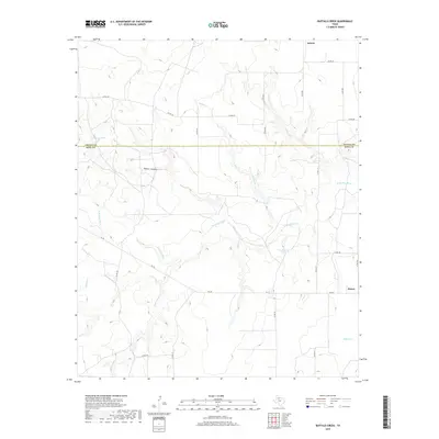
2019 Map of Buffalo Creek
USGS Topo · Published 2019About this map
N Wichita River meanders across this rural West Texas landscape where the boundaries of Cottle and King counties meet. The area is defined by a sparse network of county roads and drainage systems, with the small settlements of Delwin and Finney serving as the primary points of habitation. The terrain is marked by significant hydrological features such as Buffalo Cr and Willow Cr, which feed into the main river system, alongside man-made water sources like Dewees Tank and Hackberry Tank. These water features indicate the vital role of livestock management in this ranching country. Local geography is further distinguished by Water Canyon and Buford Br, providing a detailed look at the relief and natural drainage patterns of the region in the late twenty-first century.
Find a feature on this map
27 named features on this map. Tap any name to fly to it.
Don’t see what you’re looking for? This feature index may not catch every label — zoom into the map to look around manually.
Map Details
Editions of this 2019 Buffalo Creek Map
This is the sole edition of this map. No revisions or reprints were ever made.
Other maps of this area

1954 · Lubbock
USGS Topo · 1:250,000

1967 · Guthrie NW
USGS Topo · 1:24,000

1967 · Fourmile Hill
USGS Topo · 1:24,000

1968 · Grow
USGS Topo · 1:24,000

1968 · Buffalo Creek
USGS Topo · 1:24,000

1968 · Grow NW
USGS Topo · 1:24,000

1968 · Dumont
USGS Topo · 1:24,000
1968 · Ginsite
USGS Topo · 1:24,000

1968 · China Canyon
USGS Topo · 1:24,000

1968 · East Afton NE
USGS Topo · 1:24,000