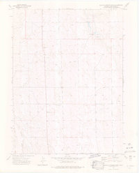
1973 Map of Buffalo Springs Ranch
USGS Topo · Published 1976About this map
Buffalo Springs Ranch serves as the primary namesake for this section of eastern Colorado, where the high plains landscape is defined by its sparse water sources and ranching utility. In the early 1970s, the terrain was marked by a series of Springs that supported local livestock operations, while Twenty-two Slough cut a natural drainage path across the southern portion of the quadrangle. The map reveals a highly functional landscape of section lines and fence lines, punctuated only by occasional infrastructure like a Gravel Pit or scattered Well sites. This survey records a specific moment in Washington County's history, documenting the remote ranching life and agricultural development of the region before further modernization. The presence of a label for Horse suggests specific land use or local landmarks that were significant enough to be noted during the 1973 field check.
Find a feature on this map
8 named features on this map. Tap any name to fly to it.
Don’t see what you’re looking for? This feature index may not catch every label — zoom into the map to look around manually.
Map Details
Editions of this 1973 Buffalo Springs Ranch Map
4 editions found
Other maps of this area

1951 · Merino SE
USGS Topo · 1:24,000

1951 · Merino
USGS Topo · 1:24,000

1954 · Sterling
USGS Topo · 1:250,000

1958 · Sterling
USGS Topo · 1:250,000

1971 · Merino
USGS Topo · 1:24,000

1973 · Akron
USGS Topo · 1:24,000

1973 · Buffalo Springs Ranch NW
USGS Topo · 1:24,000

1973 · Platner
USGS Topo · 1:24,000

1973 · Buffalo Springs Ranch NE
USGS Topo · 1:24,000

1973 · Fremont Butte
USGS Topo · 1:24,000