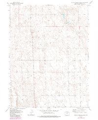
1973 Map of Buffalo Springs Ranch
USGS Topo · Published 1984About this map
Buffalo Springs Ranch serves as a primary landmark in this corner of Washington County, illustrating the isolated ranching life of the Eastern Plains. The landscape is defined by subtle drainage features and groundwater sources, including the eponymous Buffalo Springs and the elongated depression of Twenty-two Slough. These water features were historically critical for livestock in an area where human intervention is otherwise marked only by scattered wells and occasional industrial activity like the small Gravel Pit. The map shows a region organized by a strict township and range grid, with fine dashed lines indicating selected fence lines that reveal the boundaries of land use and property in the early 1970s.
Find a feature on this map
7 named features on this map. Tap any name to fly to it.
Don’t see what you’re looking for? This feature index may not catch every label — zoom into the map to look around manually.
Map Details
Editions of this 1973 Buffalo Springs Ranch Map
4 editions found
Other maps of this area

1951 · Merino SE
USGS Topo · 1:24,000

1951 · Merino
USGS Topo · 1:24,000

1954 · Sterling
USGS Topo · 1:250,000

1958 · Sterling
USGS Topo · 1:250,000

1971 · Merino
USGS Topo · 1:24,000

1973 · Akron
USGS Topo · 1:24,000

1973 · Buffalo Springs Ranch NW
USGS Topo · 1:24,000

1973 · Platner
USGS Topo · 1:24,000

1973 · Buffalo Springs Ranch NE
USGS Topo · 1:24,000

1973 · Fremont Butte
USGS Topo · 1:24,000