
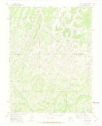
1971 Map of Bull Fork
USGS Topo · Published 1981About this map
The Rio Blanco Co Garfield Co boundary line divides this high-elevation landscape, where deep drainages and intermittent Springs define the terrain. The topography is dominated by the prominent spine of Puddin Ridge and the complex branching of Bull Fork and Willow Creek. Numerous prospects and several drill holes are scattered throughout the region, pointing to a history of geological exploration and mineral interest. A network of jeep trails provides the only access through the gulches, such as Whiskey Gulch and Stewart Gulch, which feed into the West Fork Parachute Creek. The map documents a rugged watershed shaped by seasonal water and the search for subterranean resources during the early 1970s.
Find a feature on this map
23 named features on this map. Tap any name to fly to it.
Don’t see what you’re looking for? This feature index may not catch every label — zoom into the map to look around manually.
Map Details
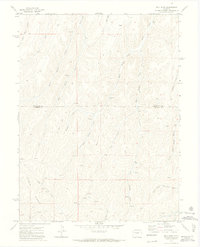
Editions of this 1971 Bull Fork Map
3 editions found
Historical Maps of Garfield County Through Time
273 maps found

1906 Grand Hogback
Garfield County, CO

1910 Grand Hogback
Garfield County, CO

1925 Parachute Creek
Garfield County, CO

1927 Parachute Creek
Garfield County, CO

1929 Grand Valley
Garfield County, CO

1929 Highmore
Garfield County, CO

1929 Roan Creek
Garfield County, CO

1952 Anvil Points
Garfield County, CO

1952 Horse Mountain
Garfield County, CO

1952 Rio Blanco
Garfield County, CO

1960 North Mamm Peak
Garfield County, CO

1960 Rulison
Garfield County, CO

1961 Shoshone
Garfield County, CO

1962 Red Pinnacle
Garfield County, CO

1962 Storm King Mountain
Garfield County, CO

1963 Center Mountain
Garfield County, CO

1963 Gibson Gulch
Garfield County, CO

1963 Hunter Mesa
Garfield County, CO

1964 Baxter Pass
Garfield County, CO

1964 Calf Canyon
Garfield County, CO

1964 Douglas Pass
Garfield County, CO

1964 Henderson Ridge
Garfield County, CO

1966 Deep Creek Point
Garfield County, CO

1966 Meadow Creek Lake
Garfield County, CO

1966 Red Elephant Point
Garfield County, CO

1966 Rifle Falls
Garfield County, CO

1966 Triangle Park
Garfield County, CO

1968 Carbonera
Garfield County, CO

1968 Garvey Canyon
Garfield County, CO

1968 Howard Canyon
Garfield County, CO

1968 Long Point
Garfield County, CO

1968 Middle Dry Fork
Garfield County, CO

1968 The Saddle
Garfield County, CO
1971 Bull Fork
Garfield County, CO

1971 Circle Dot Gulch
Garfield County, CO

1971 Cutoff Gulch
Garfield County, CO

1971 Desert Gulch
Garfield County, CO

1971 Forked Gulch
Garfield County, CO

1971 McCarthy Gulch
Garfield County, CO

1971 Mount Blaine
Garfield County, CO

1974 Adams Lake
Garfield County, CO

1974 Broken Rib Creek
Garfield County, CO

1974 Carbonate
Garfield County, CO

1977 Big Marvine Peak
Garfield County, CO

1977 Blair Mountain
Garfield County, CO

1977 Deep Lake
Garfield County, CO

1977 Devils Causeway
Garfield County, CO

1977 Dome Peak
Garfield County, CO

1977 Orno Peak
Garfield County, CO

1977 Sweetwater Lake
Garfield County, CO

1977 Trappers Lake
Garfield County, CO

2000 Devils Causeway
Garfield County, CO

2000 Orno Peak
Garfield County, CO

2010 Anvil Points
Garfield County, CO

2010 Baxter Pass
Garfield County, CO

2010 Bull Fork
Garfield County, CO

2010 Calf Canyon
Garfield County, CO

2010 Carbonera
Garfield County, CO

2010 Circle Dot Gulch
Garfield County, CO

2010 Cutoff Gulch
Garfield County, CO

2010 Desert Gulch
Garfield County, CO

2010 Douglas Pass
Garfield County, CO

2010 Forked Gulch
Garfield County, CO

2010 Garvey Canyon
Garfield County, CO

2010 Henderson Ridge
Garfield County, CO

2010 Howard Canyon
Garfield County, CO

2010 Long Point
Garfield County, CO

2010 McCarthy Gulch
Garfield County, CO

2010 Middle Dry Fork
Garfield County, CO

2010 Mount Blaine
Garfield County, CO

2010 Red Pinnacle
Garfield County, CO

2010 Rio Blanco
Garfield County, CO

2010 Storm King Mountain
Garfield County, CO

2010 The Saddle
Garfield County, CO

2011 Adams Lake
Garfield County, CO

2011 Big Marvine Peak
Garfield County, CO

2011 Blair Mountain
Garfield County, CO

2011 Broken Rib Creek
Garfield County, CO

2011 Carbonate
Garfield County, CO

2011 Center Mountain
Garfield County, CO

2011 Deep Creek Point
Garfield County, CO

2011 Deep Lake
Garfield County, CO

2011 Devils Causeway
Garfield County, CO

2011 Dome Peak
Garfield County, CO

2011 Gibson Gulch
Garfield County, CO

2011 Horse Mountain
Garfield County, CO

2011 Hunter Mesa
Garfield County, CO

2011 Meadow Creek Lake
Garfield County, CO

2011 North Mamm Peak
Garfield County, CO

2011 Orno Peak
Garfield County, CO

2011 Red Elephant Point
Garfield County, CO

2011 Rifle Falls
Garfield County, CO

2011 Rulison
Garfield County, CO

2011 Shoshone
Garfield County, CO

2011 Sweetwater Lake
Garfield County, CO

2011 Trappers Lake
Garfield County, CO

2011 Triangle Park
Garfield County, CO

2013 Adams Lake
Garfield County, CO

2013 Anvil Points
Garfield County, CO

2013 Baxter Pass
Garfield County, CO

2013 Big Marvine Peak
Garfield County, CO

2013 Blair Mountain
Garfield County, CO

2013 Broken Rib Creek
Garfield County, CO

2013 Bull Fork
Garfield County, CO

2013 Calf Canyon
Garfield County, CO

2013 Carbonate
Garfield County, CO

2013 Carbonera
Garfield County, CO

2013 Center Mountain
Garfield County, CO

2013 Circle Dot Gulch
Garfield County, CO

2013 Cutoff Gulch
Garfield County, CO

2013 Deep Creek Point
Garfield County, CO

2013 Deep Lake
Garfield County, CO

2013 Desert Gulch
Garfield County, CO

2013 Devils Causeway
Garfield County, CO

2013 Dome Peak
Garfield County, CO

2013 Douglas Pass
Garfield County, CO

2013 Forked Gulch
Garfield County, CO

2013 Garvey Canyon
Garfield County, CO

2013 Gibson Gulch
Garfield County, CO

2013 Henderson Ridge
Garfield County, CO

2013 Horse Mountain
Garfield County, CO

2013 Howard Canyon
Garfield County, CO

2013 Hunter Mesa
Garfield County, CO

2013 Long Point
Garfield County, CO

2013 McCarthy Gulch
Garfield County, CO

2013 Meadow Creek Lake
Garfield County, CO

2013 Middle Dry Fork
Garfield County, CO

2013 Mount Blaine
Garfield County, CO

2013 North Mamm Peak
Garfield County, CO

2013 Orno Peak
Garfield County, CO

2013 Red Elephant Point
Garfield County, CO

2013 Red Pinnacle
Garfield County, CO

2013 Rifle Falls
Garfield County, CO

2013 Rio Blanco
Garfield County, CO

2013 Rulison
Garfield County, CO

2013 Shoshone
Garfield County, CO

2013 Storm King Mountain
Garfield County, CO

2013 Sweetwater Lake
Garfield County, CO

2013 The Saddle
Garfield County, CO

2013 Trappers Lake
Garfield County, CO

2013 Triangle Park
Garfield County, CO

2016 Adams Lake
Garfield County, CO

2016 Anvil Points
Garfield County, CO

2016 Baxter Pass
Garfield County, CO

2016 Big Marvine Peak
Garfield County, CO

2016 Blair Mountain
Garfield County, CO

2016 Broken Rib Creek
Garfield County, CO

2016 Bull Fork
Garfield County, CO

2016 Calf Canyon
Garfield County, CO

2016 Carbonate
Garfield County, CO

2016 Carbonera
Garfield County, CO

2016 Center Mountain
Garfield County, CO

2016 Circle Dot Gulch
Garfield County, CO

2016 Cutoff Gulch
Garfield County, CO

2016 Deep Creek Point
Garfield County, CO

2016 Deep Lake
Garfield County, CO

2016 Desert Gulch
Garfield County, CO

2016 Devils Causeway
Garfield County, CO

2016 Dome Peak
Garfield County, CO

2016 Douglas Pass
Garfield County, CO

2016 Forked Gulch
Garfield County, CO

2016 Garvey Canyon
Garfield County, CO

2016 Gibson Gulch
Garfield County, CO

2016 Henderson Ridge
Garfield County, CO

2016 Horse Mountain
Garfield County, CO

2016 Howard Canyon
Garfield County, CO

2016 Hunter Mesa
Garfield County, CO

2016 Long Point
Garfield County, CO

2016 McCarthy Gulch
Garfield County, CO

2016 Meadow Creek Lake
Garfield County, CO

2016 Middle Dry Fork
Garfield County, CO

2016 Mount Blaine
Garfield County, CO

2016 North Mamm Peak
Garfield County, CO

2016 Orno Peak
Garfield County, CO

2016 Red Elephant Point
Garfield County, CO

2016 Red Pinnacle
Garfield County, CO

2016 Rifle Falls
Garfield County, CO

2016 Rio Blanco
Garfield County, CO

2016 Rulison
Garfield County, CO

2016 Shoshone
Garfield County, CO

2016 Storm King Mountain
Garfield County, CO

2016 Sweetwater Lake
Garfield County, CO

2016 The Saddle
Garfield County, CO

2016 Trappers Lake
Garfield County, CO

2016 Triangle Park
Garfield County, CO

2019 Adams Lake
Garfield County, CO

2019 Anvil Points
Garfield County, CO

2019 Baxter Pass
Garfield County, CO

2019 Big Marvine Peak
Garfield County, CO

2019 Blair Mountain
Garfield County, CO

2019 Broken Rib Creek
Garfield County, CO

2019 Bull Fork
Garfield County, CO

2019 Calf Canyon
Garfield County, CO

2019 Carbonate
Garfield County, CO

2019 Carbonera
Garfield County, CO

2019 Center Mountain
Garfield County, CO

2019 Circle Dot Gulch
Garfield County, CO

2019 Cutoff Gulch
Garfield County, CO

2019 Deep Creek Point
Garfield County, CO

2019 Deep Lake
Garfield County, CO

2019 Desert Gulch
Garfield County, CO

2019 Devils Causeway
Garfield County, CO

2019 Dome Peak
Garfield County, CO

2019 Douglas Pass
Garfield County, CO

2019 Forked Gulch
Garfield County, CO

2019 Garvey Canyon
Garfield County, CO

2019 Gibson Gulch
Garfield County, CO

2019 Henderson Ridge
Garfield County, CO

2019 Horse Mountain
Garfield County, CO

2019 Howard Canyon
Garfield County, CO

2019 Hunter Mesa
Garfield County, CO

2019 Long Point
Garfield County, CO

2019 McCarthy Gulch
Garfield County, CO

2019 Meadow Creek Lake
Garfield County, CO

2019 Middle Dry Fork
Garfield County, CO

2019 Mount Blaine
Garfield County, CO

2019 North Mamm Peak
Garfield County, CO

2019 Orno Peak
Garfield County, CO

2019 Red Elephant Point
Garfield County, CO

2019 Red Pinnacle
Garfield County, CO

2019 Rifle Falls
Garfield County, CO

2019 Rio Blanco
Garfield County, CO

2019 Rulison
Garfield County, CO

2019 Shoshone
Garfield County, CO

2019 Storm King Mountain
Garfield County, CO

2019 Sweetwater Lake
Garfield County, CO

2019 The Saddle
Garfield County, CO

2019 Trappers Lake
Garfield County, CO

2019 Triangle Park
Garfield County, CO

2022 Adams Lake
Garfield County, CO

2022 Anvil Points
Garfield County, CO

2022 Baxter Pass
Garfield County, CO

2022 Big Marvine Peak
Garfield County, CO

2022 Blair Mountain
Garfield County, CO

2022 Broken Rib Creek
Garfield County, CO

2022 Bull Fork
Garfield County, CO

2022 Calf Canyon
Garfield County, CO

2022 Carbonate
Garfield County, CO

2022 Carbonera
Garfield County, CO

2022 Center Mountain
Garfield County, CO

2022 Circle Dot Gulch
Garfield County, CO

2022 Cutoff Gulch
Garfield County, CO

2022 Deep Creek Point
Garfield County, CO

2022 Deep Lake
Garfield County, CO

2022 Desert Gulch
Garfield County, CO

2022 Devils Causeway
Garfield County, CO

2022 Dome Peak
Garfield County, CO

2022 Douglas Pass
Garfield County, CO

2022 Forked Gulch
Garfield County, CO

2022 Garvey Canyon
Garfield County, CO

2022 Gibson Gulch
Garfield County, CO

2022 Henderson Ridge
Garfield County, CO

2022 Horse Mountain
Garfield County, CO

2022 Howard Canyon
Garfield County, CO

2022 Hunter Mesa
Garfield County, CO

2022 Long Point
Garfield County, CO

2022 McCarthy Gulch
Garfield County, CO

2022 Meadow Creek Lake
Garfield County, CO

2022 Middle Dry Fork
Garfield County, CO

2022 Mount Blaine
Garfield County, CO

2022 North Mamm Peak
Garfield County, CO

2022 Orno Peak
Garfield County, CO

2022 Red Elephant Point
Garfield County, CO

2022 Red Pinnacle
Garfield County, CO

2022 Rifle Falls
Garfield County, CO

2022 Rio Blanco
Garfield County, CO

2022 Rulison
Garfield County, CO

2022 Shoshone
Garfield County, CO

2022 Storm King Mountain
Garfield County, CO

2022 Sweetwater Lake
Garfield County, CO

2022 The Saddle
Garfield County, CO

2022 Trappers Lake
Garfield County, CO

2022 Triangle Park
Garfield County, CO